Emilia Romagna, one of the Italian regions with the highest level of hydrogeological risk, was recently the victim of a “perfect storm”: several concurring elements that triggered floods and landslides with disastrous consequences.
In 24 hours, over 200 millimetres of rain fell over an area that had already been put to the test by recent bad weather conditions. At the same time, coasts were hit by a sea storm which hindered the normal outflow of rivers. These conjoined factors brought the region’s water network to collapse. More than twenty rivers burst their banks, and a similar number rose above the maximum alert level. Floods hit dozens of cities and towns in Romagna and around Bologna, and about 50 more “comuni” (municipalities) were hit by landslides between Reggio Emilia and Rimini. As of today, thousands of people were left homeless, infrastructures and businesses are severely damaged, and sadly, lives were also lost.
We discussed the situation with Enrico Bertuzzo, Professor of Hydrology at the Department of Environmental Sciences, Informatics and Statistics at Ca' Foscari University of Venice.
Key factors
The first factor: rain. In 24 hours, several months’ worth of rain fell over an area that is at high hydrogeological risk. The intensity of a river flood depends on the type of rainfall, on its duration, and on the characteristics of the water basin. Damage caused by the flood obviously also depends on the characteristics of the areas close to the rivers, and on the levels of human interference.
The maximum amount of rainwater that can be contained over a certain period of time varies for each river basin. An entire day of heavy rains may not be a problem near the mouth of the river Po, but it may be cause floods to smaller basins.
In the Emilia region, there are a number of basins similar in size along the Apennines. The heavy rains put all these basins under stress at the same time, and when the water of the rivers in spate reached the plains, it clogged the drainage network, overflowing or breaking the river banks. At the same time, a sea storm was blocking the outflow to the sea.
The situation in Veneto
In Veneto, the reservoirs feeding rivers such as the Brenta, Piave and Adige are, on average, larger at the point where they flow into the plain, and therefore easily under stress in case of longer rainfalls, for example in Autumn. In such periods, we require the managers of the mountain reservoirs to lower the water levels there: in case of floods, the volume thus made available will mitigate the effects of excessive water. We use similar actions together with tools such as detention basins and embankments in the lowlands, but an extreme event like the one in Emilia Romagna cannot be ruled out entirely.
Detention basins
Detention basins are excavated areas installed to reduce the flow of water during the flooding of a river, and to manage the controlled runoff of the rivers. Detention basins therefore function as temporary 'storage tanks' adjacent to watercourses, and are typically installed in the lowlands, next to riverbeds. When they are not used for flood management, they may serve other purposes, for example groundwater recharge or reforestation. Detention basins serve a purpose similar to that of mountain reservoirs, but over the past few decades they have often been preferred to the latter because of their lesser environmental and social impact.
The major problem with detention basins is usually their volume, which is limited: more than one basin must often be installed along the same river, and their management must be optimised. They are less complex than dams, yet their environmental impact and their cost still call for a lengthy approval process.
Solutions
No single infrastructure can protect us from floods. We must work towards a complex and articulated design, joining various elements into an efficient network: mountain reservoirs, detention basins, embankments, and also warning and response systems.
We need an integrated information system, and we must operate on several fronts at once. Response must be prompt, based on weather forecast: when alert came into being for storm Vaia, the level of Lake Corlo basin was immediately lowered, thus preventing a flood downstream, and reducing damage.
Each flood must be analysed as a separate event. Uncontrolled overbuilding, for example, can generally increase the risk, but in the case of Emilia Romagna, initial analyses suggest that this was a secondary factor, given that the rain, and the consequent flooding, occurred mainly in the Apennines.
In Emilia Romagna we were faced with an extreme event that was difficult to manage, but data and projections tell us that climate change will only make such extreme events more and more frequent. In the short term, we cannot radically change our habitats, but we can strengthen existing containment structures, invest in new infrastructures, in more maintenance work and also in more information. We need to develop tools that can alert people in real time, and everybody must be aware of the risks. The response to damage must also be managed effectively, with targeted interventions even after floods. In Italy we are culturally more focused on prevention than on response.
The 'zero risk’
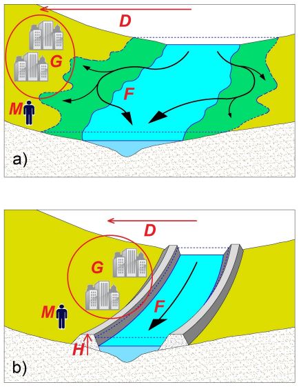
‘Zero risk’ does not exist. Our defence works are designed to withstand up to a certain volume of water, but they cannot resist all floods. Decisions are taken balancing risks and costs of the work, which takes us in the realm of socio-hydrology, which studies the interaction between society and rivers. To correctly frame what happened in Emilia Romagna, we can refer to the so called 'levee effect': building flood-control structures reduces the perception of risk and therefore favours development and human settlement in floodplain areas.
The control works reduce the likelihood of a flood, but when the flood does happen, it has catastrophic effects. This, in turn, causes to build even more flood-control systems, exacerbating the levee effect. Over the past century, this is exactly what has happened in the Po Valley. Seeing recent history in these terms may not provide us with short-term solutions, but it can help us plan for the future.


